Konstantinopoli03.jpg
Kohteesta Ortodoksi.net
Tämän esikatselun koko: 476 × 600 kuvapistettä. Muut resoluutiot: 190 × 240 kuvapistettä | 592 × 746 kuvapistettä.
Alkuperäinen tiedosto (592 × 746 kuvapistettä, 838 KiB, MIME-tyyppi: image/jpeg)
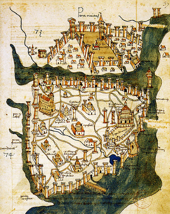
The oldest surviving map of Constantinople, dated from 1422. The fortifications of Constantinople and of Galata, at the northern shore of the Golden Horn, are prominently featured. The water trench in front of the Theodosian walls at the western end of the city is also depicted, as well as the Maiden's Tower in the middle of the Bosporus.
Wikipedia.org
Kuvan julkaisulisenssi: GDFL
Tiedoston historia
Päiväystä napsauttamalla näet, millainen tiedosto oli kyseisellä hetkellä.
| Päiväys | Pienoiskuva | Koko | Käyttäjä | Kommentti | |
|---|---|---|---|---|---|
| nykyinen | 26. heinäkuuta 2009 kello 18.00 | | 592 × 746 (838 KiB) | Petja (keskustelu | muokkaukset) | The oldest surviving map of Constantinople, dated from 1422. The fortifications of Constantinople and of Galata, at the northern shore of the Golden Horn, are prominently featured. The water trench in front of the Theodosian walls at the western end of th |
- Et voi tallentaa uutta tiedostoa tämän tilalle.
Tiedoston käyttö
Seuraavalta sivulta on linkki tähän tiedostoon: